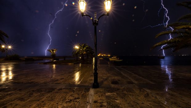
The Bad Weather “ARIEL” The National Meteorological Service (EMY) has released and is hitting the country in the last few hours Updated Emergency Severe Weather Notice.
The main characteristics of the bad weather – which also affects Attica – will be heavy rain, heavy precipitation, high frequency of lightning in sea-coastal areas and stormy winds, which will last until Thursday night. 7 to 8 Beaufort.
read more: Severe Weather Warning ARIEL – See which areas it will blow over the next few hours [χάρτης]
Areas affected by bad weather include the Ionian Sea. In fact, a corresponding message was also issued by 112 for dangerous weather events, asking residents to limit their movements.
Areas affected
According to the latest EMY data, heavy rain and storms will occur during the next few hours:
- Thursday (01-12-2022) until noon in Ionian, Peloponnese, Western and Eastern Styria (including Attica), Evia and Western and Southern Crete.
- In Central Macedonia, Thessaly and Sporades from Wednesday (30-11-2022) morning to Thursday (01-12-2022) noon.
- In East Macedonia, Thrace, North and East Aegean Islands and Dodecanese Islands from early morning to late evening on Thursday (01-12-2022).
Category 4 precipitation event
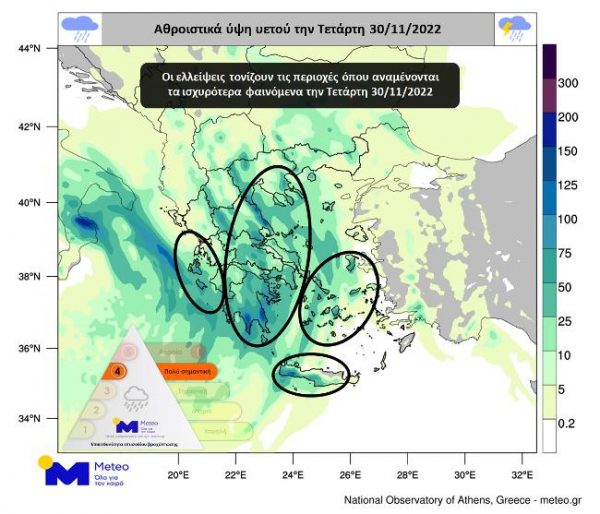
According to the latest forecast data from the National Observatory of Athens/meteo.gr, the rain episode expected during these two days is classified as category 4 (very important).
The main features of a severe weather wave are heavy rains and thunderstorms, hail at places, increased electrical activity and very strong winds.
The forecast map below shows Wednesday’s estimated rainfall totals.
At the same time, heavy snowfall will occur in the mountains of central and northern Greece.
The following are highlighted:
- During Wednesday, strong effects will be seen in the Ionian, Peloponnese, eastern mainland, western and southern Crete and other parts of the Aegean island from the afternoon.
- On Thursday, strong conditions will continue till afternoon in most parts of the country. After noon, strong effects will be felt mainly in northern Greece and the eastern Aegean island regions, although they will not stop in other parts of the country.
- Both the province of Attica and the city of Athens, as well as the prefecture and city of Thessaloniki, will be significantly affected, with strong effects expected mainly after Thursday’s shift.
- Strong winds with an intensity of 6-7 Beaufort will prevail over the seas.
- African dust concentrations will increase in southern countries.
- As heavy rainfall is expected in many parts of the country, flooding is likely.
New meeting at the Ministry of Climate Crisis and Civil Defense
Meanwhile, a new meeting was held at the Ministry of Climate Crisis and Civil Protection, chaired by Minister Christos Stylinidis, with the participation of Deputy Minister, Evangelos Tournas, Secretary General, Vasilios Papageorgiou, Head of the Fire Department. Brigade, as well as meteorologists to evaluate the latest weather data.
In the background of the meeting, developments in the adverse weather conditions so far were reviewed It was decided to implement 112 To send alert messages to residents depending on the trend and evolution of events in specific areas.
The Civil Defense Secretariat of the Ministry of Climate Crisis and Civil Defense is fully alert and has informed relevant government agencies, regions and municipalities of the country. Effects of severe weather events.
At the same time, the General Secretariat of Civil Defense recommends that citizens be particularly careful, taking measures to protect themselves from the risks posed by severe weather events.

. “Professional creator. Subtly charming web advocate. Unapologetic problem solver. Devoted student.”



More Stories
SYRIZA: Dimitris Papanotas exits European ballot – Kassalakis' post
SYRIZA angered by Papanoda's statements
Freddy Beleris' candidacy and reactions to New Democracy