
Google Maps has entered our lives forever and is literally in our hands, and these are its most useful functions.
Every time you start a path, There’s a good chance you’ll instinctively refer to Google Maps To guide you, as there is no more complete and up-to-date application of this type.
But even if you use it on a daily basis, There’s a good chance you haven’t been making the most of it Some of its most useful features and functions.
Google Maps has a lot of useful features and maybe it’s time to get to know them. for this reason Here are 10 features of Google Maps Which you didn’t know existed and might be useful to you.
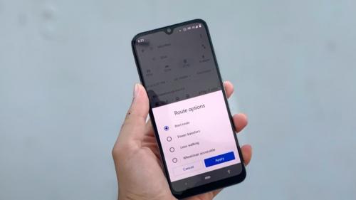
1. Check your navigation settings
Many people get stuck or delayed because they changed an important navigation setting. For example, You may have asked Google Maps to avoid toll roads and forgot to take them out. On your next trip, Google Navigator will remember the setting and potentially guide you through dangerous roads or a longer route.

Before you start your trip, Tap the profile icon on Maps and go to Settings > Navigation. In the Path Options area, make sure that you have selected the correct options. You certainly don’t want to avoid highways or tolls in most cases, so it’s best to check these settings periodically.
2. Anonymous browsing
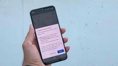
By default, Google Maps logs searches and location data unless you ask. Using incognito mode is a quick way to stop some data recording by the app. Tap the profile icon and select Enable Incognito Mode.
3. Stop the date
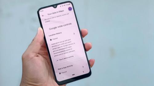
If you want to prevent Google Maps from keeping a tab on your location history, then You have to click on the profile icon and then click on your data on maps. Under Location History, click Stop.
4. Download maps for offline use
While most of us live in places with good internet connectivity, Some roads may lead to remote locations with degraded signal. If you are planning such a trip, be sure to download the maps for offline use.
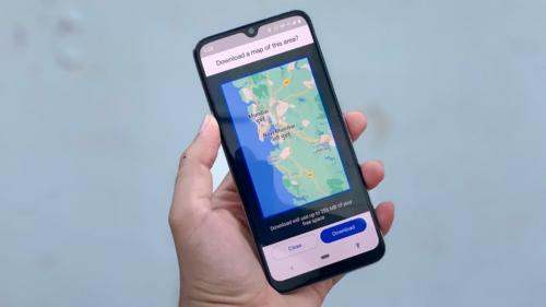
To download maps, tap your profile icon, then select Offline Maps. Accordingly, Click on Set your own map and a miniature map of the place you are will appear. All you have to do is move the blue rectangle to the area you plan to visit and press download.
5. Plan routes with multiple stops
Since you are traveling using Google Maps, you should try to add some planned stops along the way. usually Google Maps shows the quickest possible route between two locationsbut if you plan to visit some other points along the way, adding them to the route will help you get a more realistic arrival time.
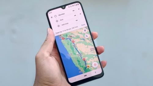
To do this, open Google Maps and plan a route first. Once you do this, Tap the three dots icon at the top right and select Add Stop. This will allow you to add an additional location, and you can drag the icon with the three horizontal lines next to each stop to move it before or after your final destination.
6. Reminder to leave
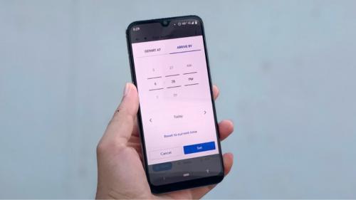
Google Maps can send you a notification about what time you need to leave in order to arrive at your destination on time. Enter the place you are leaving from and the place you are going to, then tap the three dots icon at the top right and select Set a reminder to sign out. You can choose the time you want to leave from the list, leave at and press Finish. Maps will then send you a notification at the time you choose.
7. Change the “Vehicle” icon.
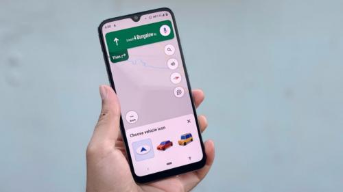
The moment you travel you can To quickly add a nice little feature to Google Maps. The default vehicle icon is a blue arrow, but if you click on it, you will see other vehicle icons available. Choose what you want and you are good to go.
8. Adjust your public transportation options
When you enter a destination into Google Maps, you’ll also see a small train icon below it. By clicking on this, You will be able to check public transportation times and available routes. In many cases it is quite accurate with the times it provides.
9. Share your location in real time
Google Maps also lets you share your location with other app users in real time. This may sound a little scary, but it can also be a useful security feature. If you feel unsafe, You can allow close friends or family members to track your location for a period of time. This feature is also useful when you go to a friend’s house and they want to know how far you are from them.
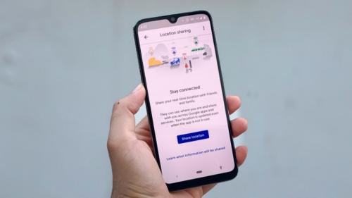
To use this feature, Tap your Google Maps profile icon, then tap Share Location. When you want to start sharing, tap 1 hour to set how long you want to share your location.
10. Information about local companies
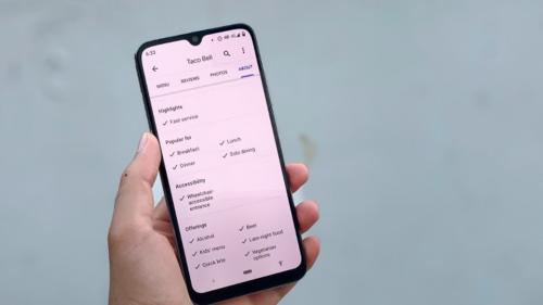
If you are not sure then Local businesses have the amenities you needyou can search for it on Google Maps, swipe right under the business name, then tap Info.
Read also

“Total alcohol fanatic. Coffee junkie. Amateur twitter evangelist. Wannabe zombie enthusiast.”

")

")
More Stories
Motorola Razr 50 Ultra Review – Review
6 Phrases That Show You’re Mentally Stronger Than Most People
Maniskin: They were honored for their overwhelming success in Greece.