
In the next few hours we expect a new wave of bad weather, mainly rain and locally strong storms – mainly in southern areas – the descent of cold air masses combined with the movement of low pressure will cause snowfall mainly at low altitudes. Northeast of the country.
Specifically, according to his available predictive data meteo.gr/National Observatory of Athens On Tuesday (09/01), rain and local storms will occur mainly in the eastern and southern regions, the events will be intense in the Cyclades, Crete, the eastern Aegean islands, the Dodecanese and the southern Peloponnese.
The mercury will fall from early Tuesday morning, while Attica and further south will see a chill from the afternoon.
Snow falls at low altitudes in the mountainous and semi-mountainous areas of Macedonia, Thessaly and Evia, as well as in Thrace and the northeastern Aegean islands.
Estimated cumulative rainfall up to and including Tuesday 09/01/2024.
Perceptible drop in temperature
ERT's meteorologist, Sakis Arnautoglou, predicts a significant drop in temperature, which will be felt in the morning hours (09/01) in the north, while in Attica and further south from the afternoon hours.
His colleague, Clearkos Maroussakis, predicted that “the first snows will appear in the mountains of Attica province at an altitude of approximately 600 meters and above. Therefore, those with a mind will see snow flakes falling on the peaks of Barnitas, Bendeli, Kithirona and Ymitos on Wednesday, e.g. Ymittos peaks and many more Centimeter layer of snow e.g. on top of Mt Barnita”.
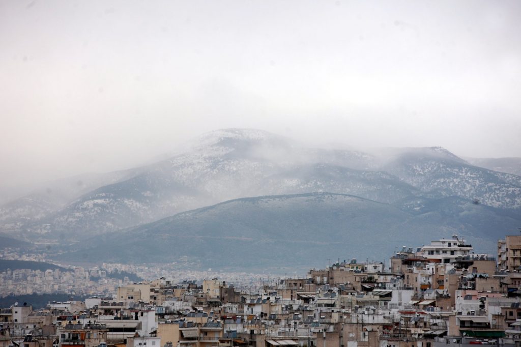
Pani Parnita
Meanwhile, according to the Rain Episode (Regional Precipitation Index) classification used by the Meteo Unit of the National Observatory of Athens, Tuesday's rain episode is expected to be the most intense event, categorized as 3 (notable).
Local hail in the Cyclades, Crete, Dodecanese and southern Peloponnese
– Significant strengthening of winds in the Aegean, where they blow from northerly directions to nearly storm force 7 Beaufort and inland north Aegean storm force 8 Beaufort
– A significant drop in temperature, which will be especially noticeable in the north and then in the east.
First predictions for the weekend
A second wave is expected by the end of next week. It is not excluded that snow will fall again in the mountains of Attica, which will also affect the northern suburbs.
The severity of the events over the weekend will be evident in the next 24 hours
National Meteorological Service (NMS) Director Theodoros Kolitas talks about both cold invasions. First on Tuesday and Wednesday and another over the weekend, snow fell in Attica.
As for the snowfall for this coming Saturday, there are large discrepancies between the forecast models in terms of snowfall amounts, and this is due to the different locations of the surface low.
📌 Two cold invasions will be marked this week, the first on Tuesday Wednesday and the other over the weekend.
✅ Regarding the snowfall next Saturday, the amount of snowfall and this… pic.twitter.com/VaeKBBL5wa
— Theodoros Kolitas (@kolidasti) January 8, 2024
Mr. According to Kolitas, the next 24 hours will settle things down so that we can better assess the weather conditions for the weekend.

. “Professional creator. Subtly charming web advocate. Unapologetic problem solver. Devoted student.”


More Stories
Rhodes: Criminal organization that smuggled migrants from Turkey to Greece dismantled
Rhodes: How EYP arrived at the arrest of the Syrian leader of a migrant smuggling ring – €5,000 per person charge
“Campanagi” for Crete: Risk of general drought is visible on the island