The weather is expected to deteriorate rapidly in the next few hours, initially with a steep drop in temperature followed by heavy snowfall affecting many parts of the country.
According to the latest data, heavy snow is expected in SE Thessaly, Eastern Styria, Evia and even the Northern Sporades from Monday night and Tuesday.
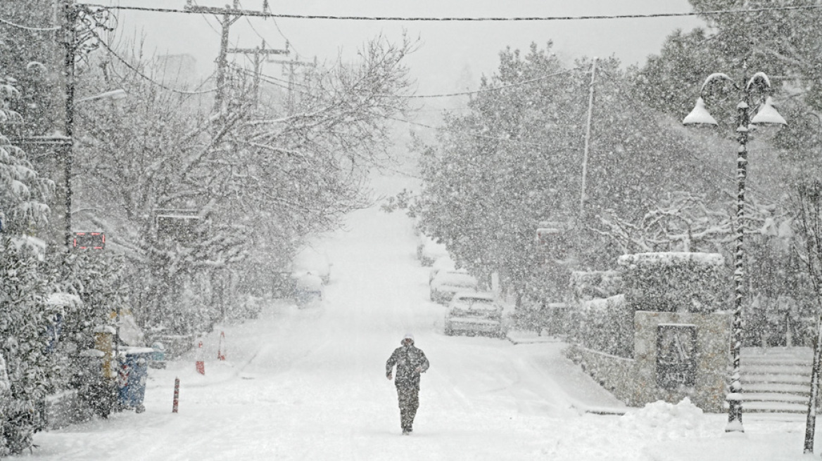
Snow in Athens too
Snow reaches even lower altitudes in these regions.
Snowfall is expected in Attica from Monday evening, even in the center of Athens, although it will “spread” in areas at altitudes of 200 to 250 meters and above.
Heavy snowfall is expected in the northern suburbs and the more mountainous parts of the province, causing traffic difficulties.
Civil Defense Alert
Due to the impending bad weather, the government machinery is on alert and emergency meetings have been initiated in civil defense to coordinate efficient systems and take preventive and emergency measures.
The Ministry of Climate Crisis and Civil Defense's newly established Risk Assessment Committee met at noon on Saturday and will meet again on Sunday at 12 noon. At 13.00 there will be a meeting of the Inter-agency Committee with the objective of operational coordination of all concerned Ministries and Institutions.
The inter-ministerial committee is also expected to take decisions on the implementation of emergency measures, which will come into effect during bad weather and if events are severe with heavy snowfall and snowfall.
Curfew
According to the information and data available so far, significant sections of the national road between Athens and Larissa are expected to be affected by snow, so preventive measures will be taken to limit the traffic of large vehicles.
Forced chains
The police are expected to issue appropriate regional-wise decisions regarding drivers having anti-skid chains on their vehicles and knowing how to install them. The move is expected to take effect in most of Attica as well.
Activities for workers and schools
The relevant ministries will announce a series of measures and recommendations to employees and employers on how the government and private sector will operate.
As for the operation of schools, local regions will decide which areas will be closed mainly on Tuesday morning, unless the bad weather is generalized to more than one region, with decisions made by the Ministry of Education. .
112 will also ring
However, around noon on Sunday, the EMY's emergency bulletin for severe weather will be updated and meteorologists will inform concerned agencies about how, when, and how the severe weather will move. It lasts a long time.
Tomorrow it will be evaluated and warning message 112 will be sent to the areas with recommendations for citizens to be especially careful and limit their movements.
When does bad weather hit?
According to mega meteorologist Giannis Kallianos, the bad weather will last for four days from Sunday to Wednesday. Snowfall is expected in the Aegean and eastern continents, but a temperature drop of 8-10 degrees Celsius and 8-9 northeast of Beaufort.
Snow is expected at low altitudes in eastern Thessaly, Central & East Central Greece, Evia, Sporades, Northeast Aegean, Eastern Peloponnese and Crete.
As far as Attica is concerned, snowfall will be mainly in the northern suburbs, according to the latest forecast, snow is possible in Dionysos, Ekali, Rhodopoli, Trosia, Penteli, Trafi, Trachomakedons, Krioneri, Anixi and Saint Stephen.
Police referrals
In a statement issued by EL.AS. In view of the adverse weather events expected to hit the region, police services of all countries have been put on full operational alert and steps have been taken to take action and provide assistance wherever necessary, with the cooperation of all. Co-efficient agencies.
In this case, according to the notification of EL.AS. And with the primary objective of protecting the citizens, it is recommended to regularly update the prevailing weather and condition of the road network, as well as to avoid unnecessary travel.
Strict regulations for anti-slip chains
If movement is necessary, citizens are advised to exercise particular caution and strictly follow the instructions of the traffic police to avoid accidents.
At the same time, it is recalled that if the results are issued by the competent police services, it becomes mandatory to use anti-slip mechanisms, recommended to be available on a permanent basis in their vehicle in order to avoid inconvenience.
For this, strict controls will be carried out by special teams at key points on the road network.
EMY's new emergency
Late Saturday night, EMY updated the emergency bulletin for severe weather.
Emergency weather bulletin issued on 27-01-2024/1100 updated as per latest forecast data.
The weather will gradually deteriorate today with two interruptions from noon on Sunday (28-01-24) and on Monday (29-01-24) and Tuesday (30-01-24). A more serious phenomenon emerges through the second disturbance.
The main features will be a significant drop in temperature over the three days of Sunday-Tuesday (order of 10°C) and snowfall, mainly from the heights of Thessaly and further south in the eastern winds of the country.
At the same time, stormy northerly winds will prevail in the Aegean region and strong rains and storms will occur mainly in the southern sea-coastal areas.
More details:
A. Snow falls on:
a) Today Sunday (28-01-24) from the morning, there will be snow in the mountains of Macedonia and Thrace, Thessaly, Central and Eastern Styria, Evia and the Peloponnese, and in the mountains in the afternoon. Crete
b) On Monday (29-01-24) light snow will continue in the lower altitude areas of Macedonia and Thrace from morning. Heavy snowfall is forecast for Thessaly, Sporades, East and Central Styria, Evia and the northern and eastern parts of the Peloponnese from midday on Monday. Snow also occurs in the Aegean islands (in the mountains) and in the mountainous and semi-mountainous areas of Crete.
In particular, for Attica, the intensity of snowfall is predicted from the afternoon of Monday (29-01-24) in mountainous and semi-mountainous areas and in low-altitude areas from the evening.
c) Snow will continue on Tuesday (30-01-24) in Thessaly, central and eastern Styria (including Attica), Evia, Sporades, northern and eastern parts of the Peloponnese and low altitude areas in mountainous and semi-mountainous areas. North and East Aegean, Cyclades and parts of Crete.
d) On Wednesday (31-01-24) the snow will gradually weaken and remain confined to the mountains and semi-mountains of Crete.
B. Northeast wind 8 to 9 and locally 10 Beaufort:
a) Tuesday morning (30-01-24) in the north and gradually in the central and southern Aegean.
b) On Wednesday (31-01-24) stormy northerly winds will be maintained over the Aegean but from midday in the north they will be limited to 8 Beaufort and gradually weaken.
C. Heavy rain and storm Today Sunday (28-01-24) the first disturbance is predicted in places in Evia and Crete and mainly from Monday (29-01-24) afternoon to Tuesday (30-01-24) the second disturbance mainly in Sporades , Evia, Cyclades and Crete.

. “Professional creator. Subtly charming web advocate. Unapologetic problem solver. Devoted student.”


More Stories
Schools: Last week of classes for high schools – when do elementary schools close?
Stefanos Kasselakis: “Come here and say it” – a disarming response to homophobic attacks
It was my most beautiful visit to Athens