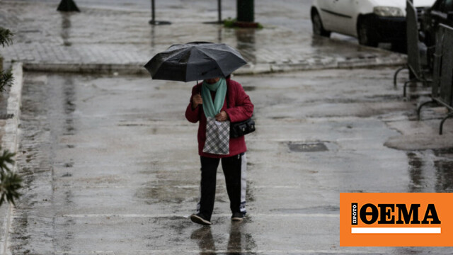
The weather will worsen From Thursday night (13-10-2022) till Sunday (16-10-2022) morning Western and Southern Greece Heavy rain and storms with high frequencies of lightning, hail and, occasionally, strong winds during the events.
Additional information:
from Today Night (13-10-2022) and till Friday Afternoon (14-10-2022) Heavy rain and storm Expected in the Ionian Islands, Epirus and Western Styria.
Tomorrow Friday (14-10-2022) Strong events will affect the western Peloponnese from early morning until midday. Eastern Peloponnese West Cyclades gradually from late afternoon.
Sometimes they are serious Rain in southern parts of Thessaly And in the center Solid.
The Saturday (15-10-2022) West and heavy rains and storms are expected Southern Cyclades and Crete.
Events in the Cyclades in the afternoon They will become weak, but they persist in Crete, while they also affect the Dodecanese in places. Weakening of events is expected in Crete and Dodecanese Sunday morning (16-10-2022).
A low pressure system will move from the southern part of Italy To our country The weather will change from Thursday afternoon 13/10 until Saturday 15/10 with strong benefits, temporarily Falling temperatures and strengthening winds in the Aegean. The precipitation episode for Friday 14/10 will be Category 3 according to the Regional Precipitation Index (RPI), developed and implemented at the National Observatory in Athens. meteo.gr
In more detail, they will take place from the afternoon of Thursday 13/10 In the northern Ionian while it rains in western Macedonia and Epirus Storms are also expected. Gradually, until the morning of Friday 14/10, the rain will extend to the rest of the Ionian Sea, excluding the mountains of East Macedonia and Thrace, Sporades, Cyclades and Crete. Storms occur in the Ionian and western and southern continental areas. Impacts will be strongest in the Ionian, Western Continent and Peloponnese.
Rain and storms from Friday night 14/10 to Saturday 15/10 Mainly occurring in Steria, Peloponnese, Central and South Aegean and Crete with stronger events expected in Peloponnese and Crete. From the afternoon of Saturday 15/10 events will be limited to Evia, Eastern Continent, Central and Southern Aegean and Crete.
Friday 14/10 temperatures will show a temporary drop in the Ionian and on the mainland and Saturday 15/10 in Crete, but by Sunday 16/10 it will return to Thursday 13/10 levels. Northerly winds will gradually strengthen in the Aegean, not exceeding 4 to 5 Beaufort on Friday morning and reaching 6 to 7 Beaufort in places from Friday night 14/10 to Saturday 15/10.
The associated video shows the low pressure, wind and rain expected from midday on Thursday 13/10 to the morning of Sunday 16/10.
Development of bad weather
Starting this evening, that changes rapidly WeatherInitially in northwest Greece, the same time will be with us from Friday degeneration and the rain In many areas but not across the territory.
Areas affected by inclement weather Western and central Greece and western Macedonia will be, until Thursday evening central Macedonia and Northern Peloponnese. Winds in the west will be moderate southwesterly 2 to 4 beaufort, while the Aegean north will be 4 to 5, reaching the central Aegean and Carpathian seas 6 to 7 beaufort.
The temperature does not drop below 11 degrees, except in the highlands of Thrace and the Peloponnese and central Greece, which reach 5 to 7 °C. By noon, the mercury will not be above 25 to 26 degrees.
Temperature in Attica Expect highs of 17 to 26 degrees with some clouds and 3 to 4 Beaufort winds.
Orange in the diagram below Geographical sectors most likely to experience severe weather events from the wave of severe weather we expect over the next few hours are highlighted.

Marine – Coastal geographic areas show a higher risk Flood events. A final warning concerns the western and southern seas, as a storm northerly will prevail over much of the Aegean, which will “block” the instability.
Be careful in the areas near the mountains on Saturday and in Evia, because contact with the northern terrain can create severe weather inland, Kleichos Marousakis warned on his personal Facebook page.
Weather at a glance
Clouds with localized rain in the west, center and north will intensify from late afternoon and locally strong in the evening
-The temperature 23 to 26 degrees Celsius
-The 4 to 6 and domestically the Dodecanese are 6 to 7 Beaufort
Clouds are expected to gradually increase in the west, center and north with localized rain. Storms will develop in the Ionian, Epirus and Western Mainland from the afternoon and their effects will be widespread in the evening.
Remaining areas will have few clouds which will gradually increase over continental areas.
Visibility will be locally low and fog is likely to develop over continental areas, mainly in western areas during the morning and evening hours.
Winds will become light westerly and gradually southerly at 4 to 5 Beaufort. In the east they blow from 3 to 5 northerly and up to 6 Beaufort in the Aegean.
Temperatures range from 21 to 23 degrees Celsius in the north and 25 to 26 degrees Celsius in other parts.
Macedonia, Thrace
Weather: In western and central Macedonia, temporarily increased clouds with local rain are forecast, which will gradually intensify from the afternoon. Clouds will gradually increase in remaining areas.
Winds: Variable 3 to 4 Beaufort and east northeast locally up to 5 Beaufort.
Temperature: 11 to 23 degrees Celsius. Maximums will be 3 to 4 degrees lower in western Macedonia.
Ionian Islands, Epirus, Western Mainland, Western Peloponnese
Weather: In the Ionian Sea, Epirus and Western Styria, clouds are forecast to increase temporarily, local rain will intensify and storms will occur from the afternoon. Its impact will be higher in many places from evening onwards.
In the western Peloponnese, a few clouds will gradually increase and there will be local rain and scattered storms during the night.
Winds: Changeable patients will turn to southerlies from before noon, strengthening between 4 and 5 pm and locally 6 Beaufort in the Ionian.
Temperature: 14 to 26 degrees Celsius. In the interior of Epirus it is 5 to 6 degrees lower.
Thessaly, Eastern Continent, Eastern Peloponnese
Weather: A few clouds, mainly in Thessaly and Central Styria, increased temporarily from the afternoon, with local rain.
Winds: Northeast 3 to 4 and East local 5 Beaufort.
Temperature: 13 to 26 degrees Celsius.

Cyclades, Crete
Weather: Mostly sunny with some local clouds.
Wind: Northwest 5 to 6 Beaufort.
Temperature: 17 to 25 degrees Celsius.
Eastern Aegean Islands – Dodecanese
Weather: A few clouds increasing from the afternoon over the eastern Aegean islands. It’s usually sunny in the Dodecanese.
Wind: North 5 to 6 Beaufort.
Temperature: 17 to 26 degrees Celsius. 2 to 3 degrees decrease in the north.
EUBOEA
Weather: A few clouds increasing from afternoon.
Wind: Northeast 3 to 5 and south inland to 6 Beaufort.
Temperature: 15 to 24 degrees Celsius.
Attica
Weather: A few clouds increasing from afternoon.
Winds: Northerly 3 to 4 and east locally 5 Beaufort.
Temperature: 15 to 25 degrees Celsius.
Thessaloniki
Weather: Temporarily increasing clouds with light localized rain. Rain will intensify in the evening.
Wind: Variable 3 to 4 Beaufort.
Temperature: 14 to 22 degrees Celsius.
Forecast for tomorrow Friday 14-10-2022
In the Ionian, mainland (except Thrace), Sporades and Evia, clouds with rain and occasional storms are forecast. Effects will be stronger in the Ionian, Epirus and western mainland until the afternoon and in the western Peloponnese until the afternoon. In other parts of the country, clouds are forecast to increase temporarily with localized rain, from the afternoon in the north-eastern Aegean, from the afternoon in the Cyclades and Crete and in the evening in Thrace and the Dodecanese.
West, Central and North, East Northeast 4 to 6 Beaufort and other parts East Southeast with same intensity.
Temperatures will drop and will not exceed 18 to 21 degrees in the West and Macedonia and 22 to 23 degrees in other areas. .
News Today:
Champions League: Fastest hat-trick in competition’s history and 34 goals on the night – watch video
Greece-Turkey: A De-Dramatization of KYSEA – Maximos and Staff Assessments
12-year-old girl raped: Girl’s father also arrested for drugs

. “Professional creator. Subtly charming web advocate. Unapologetic problem solver. Devoted student.”


More Stories
May Day: Who will take part in Wednesday's strike – without ships, how will the means of transport move?
B. Kigilias: Emergency meeting on civil defense due to multiple and simultaneous explosions
The number 1 of the gangster criminal organization “Contos” is in prison