A change in weather is expected from the afternoon and from the northwest as the cold air from Central Europe approaches our country.
It remembers from its first pass Bad Weather “B” Rain and scattered storms yesterday created problems in the Achaean regions with locally strong events.
According to forecast data for the morning of Friday 03/11 quoted by meteo.grStrong locally in the afternoon Showers and storms will begin to appear in the northern Ionian Islands, with events extending to Epirus in the eveningIn parts of western Macedonia and elsewhere in the Ibtani Islands and on the western mainland.
Meteo.gr reports that local rainfall of less intensity will also occur in Thrace and the island regions of the Eastern Aegean. Atmospheric conditions will favor hail in the northwest and dust transport from Africa. At the same time, winds from southerly directions will strengthen to 5-6 Beaufort in the Ionian and northern Aegean.
Watch the evolution of weather events live:
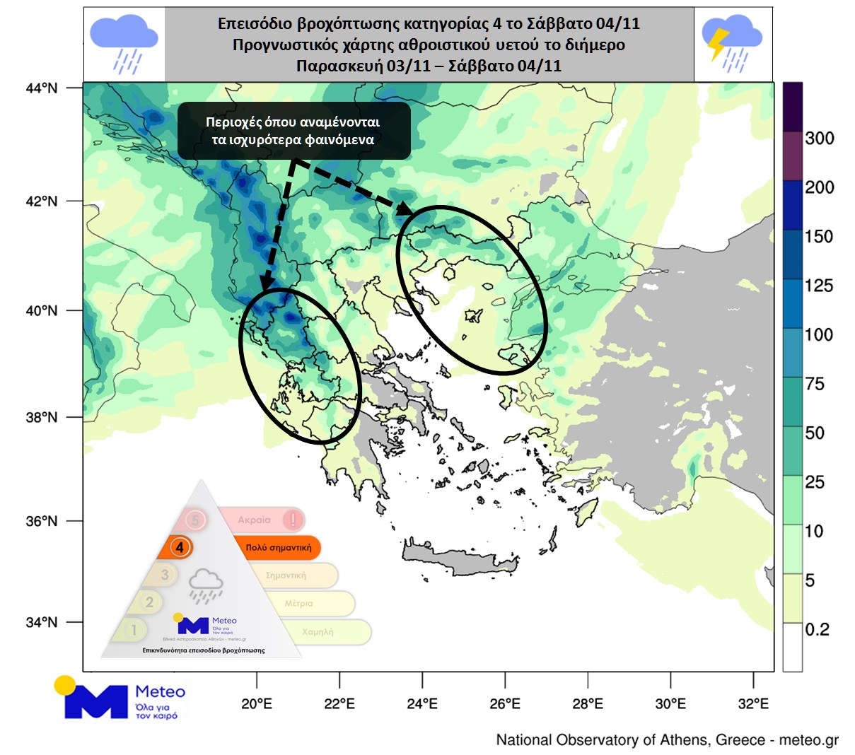
On Saturday, the front will cross the country and move eastward. As a result, showers and storms will occur over most of the mainland and northern and eastern Aegean islands until the afternoon.
A large amount of water will be obtained continentHowever, as the rainfall episode is classified as category 4 (very important), the effects will be strong in many parts of the country.
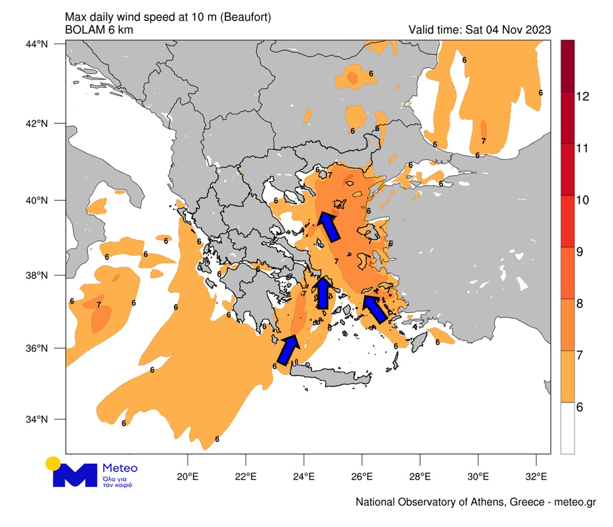
Hail showers mainly in west and north. Temporary storms are expected in the province of Attica and in the city of Athens. In the Aegean the southerly winds will show a significant strengthening, their intensity will reach 7-8 Beaufort (Table 1), with high waves, over 4 meters. At the same time, the concentration of African dust in the atmosphere will increase.
Accordingly meteo.gr, Saturday 04/11 Afternoon events will gradually become confined to the northeast where strong storms with gusty winds will continue inland. The weather is expected to clear from Saturday night.
On Sunday 05/11 the weather will improve in most parts of the country and only some rain is forecast in the Epirus and Pindos mountains and above 2,000m there will be some to light snow. Temperatures will drop across the country.
Civil Defense Recommendations for Citizens
In this context, the Chief Secretariat of Civil Defense recommends that citizens be especially careful. Taking self-defense measures from Risks from extreme weather events.
Especially, in areas Heavy rain, thunderstorms or strong winds are expected:
- To protect items that could cause damage or injury if carried by severe weather.
- Make sure the house’s gutters and downspouts are unclogged and working properly.
- Avoid crossing streams and creeks on foot or by vehicle during storms and rains, but for a few hours after their occurrence.
- Avoid outdoor work and activities in ocean and coastal areas during severe weather events (risk of lightning).
- Take shelter immediately during a hailstorm. Take shelter in a building or car and do not leave a safe area until they are sure the storm has passed. Hail is also very dangerous for animals.
- Avoid going under large trees, under posted signs and in public areas where light objects (eg pots, broken glass etc) can break and fall to the ground (eg under balconies).
- Faithfully following the instructions of local authorities like traffic.
In areas with intense lightning activity:
If you are at home
- Do not hold electrical appliances or telephones as lightning may pass through the wires. Disconnect TV sets from antenna and power supply.
- Avoid touching plumbing pipes (kitchen, bathroom) as they are good conductors of electricity.
If you are in a car
- Park it on the sides of the road and away from trees that fall on it.
- Stay inside until the storm clears and turn on the stop warning lights (hazard lights).
- Close windows and do not touch metal objects.
- Avoid flooded roads.
If you are outside
- Take shelter in a building or car or sit on the ground immediately without lying down.
- If you are in the woods, take cover under the sturdy branches of low trees.
- Do not stay under a tall tree in the open.
- Avoid low-lying areas prone to flooding.
- Do not stand near power poles, power lines, telephone lines and fences.
- Do not access metal objects (eg cars, bicycles, camping equipment, etc.).
- Stay away from rivers, lakes or other bodies of water.
- If you are in the ocean, get out immediately.
- If you are isolated on a flat surface and feel your hair stand on end (signaling that lightning is about to strike), sit with your head deep between your legs (minimize the surface area of your body and contact with the ground). Metal objects you have.
For information and announcements Regarding the current condition and passability of the road network Citizens can visit the EL.AS website as the flood water comes in. www.astynomia.gr.
Further Self-care information and instructions From severe weather, citizens can visit web page of the Chief Secretariat of Civil Defence at the email address civilprotection.gov.gr

. “Professional creator. Subtly charming web advocate. Unapologetic problem solver. Devoted student.”


More Stories
Michaloliakos: Publication – a bombshell, an appeal and a serious “crime”
Nikos Michaloliakos: Why is he getting out of prison – what is the basis of the Judicial Council's decision?
Crete: Relative of man who shot dead 23-year-old in Kastelli